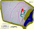
Trackplan
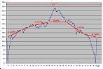
Based on a survey of the property, I'm intending to have the track slope East to West, with the Eastern end being lower
at about 820 feet above sea level. The grades are unavoidable if I want any decent running length, plus they make operation more interesting.
The current plan calls for over 1800 feet of track - that's over 1/3 of a mile!
Aside from the "usual" issues of time, money, and labor, building the RR has two particular challenges:
1) The terrain is very rough, and is full of boulders and trees.
2) The "lower" part of the loop crosses a marshy area - a long, tall trestle (like this, or perhaps a covered bridge!) will be required.
I'll certainly need many hours in a tractor to create the basic grade, and I plan to save the trestle for
last - a sort of victory celebration. Plus it'd be kinda stupid to build the trestle first then never complete
the rest of the track :)
Trackplan (topo map) (click image to expand it)
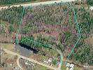
Trackplan (Aerial image) (click image to expand it)
Profile (click image to expand it)